
The CDO Hearings took place on September 24, 2024, and October 1, 2024. The Plan Commission took note of all public comment, and will be holding Administrative Meetings to go over the public testimony. Some of the public testimony was directed towards Planning Staff as questions (answered below), and some testimony was directed towards the Plan Commission to make a decision on whether to incorporate the requested changes into the CDO during their Administrative Meetings (packet link here).
Q&A from the CDO Hearings, Written Public Testimony, and other Items entered into the record until October 6, 2024:
Comments/Questions regarding Subdivision Options in the CDO:
We received several comments and questions regarding subdivision options under the CDO. Upon reviewing the meeting minutes from the hearing and written testimony received, we believe the following information should be shared:
There are three subdivision options that exist in the CDO, as well as the current ordinance, to create new buildable lots:
- Major Subdivision: typically 5 or more lots created. This option includes requirements to build out public improvements, such as roadways, sidewalks, street trees, stormwater infrastructure, sewer, etc.
- Minor Subdivision: 4 or fewer lots created. This option can be achieved either with lots connected to sewer, or on lots connected to septic. If connected by septic, 4 lots, each 10 acres or greater, can be created.
- Sliding Scale Subdivision: 4 or fewer lots can be created. This option is for rural areas only on septic systems. This option allows subdivisions to occur that have smaller lot sizes (2.5 acres) with the “parent parcel” being 55% of the size of parcel prior to subdivision. This option requires a notation on the secondary plat and deed: “The designated Parent Parcel Remainder shall not be further subdivided for a period of twenty-five (25) years from the date of recording of the Final Plat. This Restriction shall be recorded on the Final Plat and incorporated as a Recorded Commitment (which states the day, year, and month in which the Parent Parcel Remainder becomes eligible for further subdivision) referenced on any deed conveying the Parent Parcel Remainder.”
We received several comments/questions about the Sliding Scale provision, such as a request to remove the 25 year restriction, or allow more than 4 lots to be created. By removing the 25 year restriction, we believe the intent would be then to resubdivide the area into more lots than 4 and therefore the request is really to allow more than 4 lots to be created under the Sliding Scale Option initially. This topic will be discussed during the Plan Commission Administrative meetings beginning on October 23, 2024, and possibly continuing until November 1, 2024. Please see the Events Calendar for CDO Work Session dates: https://www.co.monroe.in.us/egov/apps/events/calendar.egov?view=cal.
Comments/Questions on Subdivisions in the CDO:
- Comment: Can more than 4 lots be created under the Sliding Scale provision?
Answer: Planning Staff reached out to the Highway Department to receive perspective on why 4 lots is the correct limitation for the rural context. The Planning Department sees the limitation of 4 lots or less to be important in encouraging development to go where there is access to sewer, water, fiber internet, public transit, commercial area access, etc.
From the MS4 Coordinator: The stormwater ordinance now gives us the ability to require detention for any subdivision, but I haven’t implemented it yet for minor subdivisions. I may only consider it for minor subdivisions in critical watersheds, or areas with multiple pieced-together minor subdivisions. But since common area lots aren’t created in these smaller subdivisions I’m having a hard time figuring out what it would look like. This is something I’d like to discuss with the Drainage Board as well. Other programs in the state implement detention for minor subdivisions so I can also ask around to see how they do it.
From the Highway Engineer: Subdivisions including more than 4 lots should have a requirement to build out roadway improvements (i.e. be a major subdivision). The subdivisions that exist on private roads have issues that always come up and include utilities and easement access issues between the multiple property owners. In many cases the roadways fall into disrepair and the property owners want the County to take over the road for maintenance purposes.
2. Question: Please confirm all subdivision options available to people without sewer.
Answer: Technically, all subdivision options are available to properties without sewer and on septic. It requires, though, a minimum of 10 acres.
3. Question: The term “Contiguous” 1 acre requirement is a concern for Sliding Scale subdivisions.
Answer: this has since been changed to “Buildable Area” and the word contiguous is only for lots in the ECO.
4. Question: Ch 833 Assurances for Improvements: does the guarantor have to be within 60 miles of Bloomington?
Answer: Yes, staff does have to make the drive from time-to-time to collect letters of credit. The use of County vehicles and Staff time is a justification for this standard. To cash a letter of credit, we must go to the bank in person (a requirement to obtain the funds). This is a vital provision and Legal has asked us to keep this in.
5. Question: Can there be incentives or an ability under the CDO to use green infrastructure for subdivisions?
Answer: There are now a variety of options instead of just stormwater detention basins. We suggest meeting with them to go over options under the Stormwater Ordinance (link here).
6. Comment: Do not require road frontage for subdivisions. Allow subdivisions off of private roads and easements.
Answer: We have since revised this section to relate back to how the ordinance is currently written. It does not require road frontage for subdivisions.
Comments/Questions on the Definitions in the CDO
6. Question: During the Hearing, someone requested information on the permissions for holding educational programming or field days on agricultural properties in the County. They had reviewed the Agricultural Event Center standard, which limits the number of events to 40 per year, limits the number of people to 300 maximum based on total acreage, and limits the hours of operation from 10:00 a.m. to 11:00 p.m. on Friday and Saturday and from 10:00 a.m. to 8:00 p.m. Sunday through Thursday.
Answer: Planning staff believes that educational programming and agricultural field days held on an agricultural property better fit traditional agriculture or agritourism/agritainment and therefore would not be subject to the limitations under agricultural event center listed after the use table in Chapter 811. The following definitions provide clarity in the CDO:
Agriculture, Traditional: A use involving the science and art of the production of plants and animals including to an incidental extent the preparation of these products for human use and their disposal by marketing or otherwise. This use may include, but is not limited to, farming (including plowing, tillage, cropping, livestock, and installation of best management practices, seeding, or cultivating), harvesting for the production of food and fibers (except commercial logging and timber harvesting), horticulture, dairying, sugar making, aquaculture, viticulture, poultry, and exotic animals. May include the presence of a residential use on the same lot. Includes, but is not limited to, row crops, pasturage for animals (does not include intensive agriculture), Land Animal and Non-Animal Related uses, Commercial Non-Farm Animals, Horse Farms, Orchards and Stockyards. Structures, including but not limited to Grain Elevators, are also permitted as part of this use.
Agricultural event center: Agricultural Event Center: An event center that is accessory to a primary agricultural use. For purposes of this provision, an “event” is a celebration, ceremony, wedding, reception, corporate function, or similar activity for the benefit of someone other than the property owner and/or includes a business transaction in return for hosting an event.
Agritourism/Agritainment: Farming-related activities offered on a working farm or other agricultural setting for entertainment or educational purposes.
7. Question: There were several concerns regarding the accessory Livestock definition; someone requested that the Plan Commission add in an exception for short-term raising of animals, such as 4H, and that the use only be applicable for lots under 2.25 acres. Is it possible to make Accessory livestock only allowable on non-rural lots as to not conflate that it would be enforceable in the rural areas? Or put in language in the definitions section? Can staff get recommendations from Purdue on accessory livestock limitations?
Answer:
The definition for Accessory Livestock is as follows:
Accessory Livestock: Keeping domestic livestock, or poultry for personal use in a manner that is clearly subordinate to the primary residential uses on the same lot.
The allowance for Traditional Agriculture is in many of the zones in the County. If 4H involves any commercial sale of animals or is otherwise not deemed as just “personal use” then the correct use would be Agriculture, Traditional, which does not have limitations on the number of livestock until the limits under “Intensive Agriculture” are met (e.g. CAFOs).
Accessory livestock may be requested to be utilized by some property owners in the rural areas so we do not want to take away this use. Keep in mind that if you meet the definition for Agriculture, Traditional and not Accessory Livestock, then we would apply the use “Agriculture, Traditional”. We would not enforce “Accessory Livestock” limitations on a property owner if the livestock is not only being kept for personal use. It is our understanding after speaking with Purdue Extension and other professionals that most 4H participants would fall under Agriculture, Traditional; however, there may be some 4H participants in suburban contexts in which limitations would make sense and also the 4H participant may not engage in the commercial sale of the their livestock.
Since the CDO hearing, Planning Staff met with a panel of professionals put together by Purdue Extension. We did a few changes to the draft CDO (As seen in the latest draft on http://www.monroecdo.com):
- Allow Agriculture, Traditional in the Residential 1 zoning district if the lot size is at least 2 acres. It is already permitted in the other rural zones under the use table and that did not change;
- Clarified the setback requirements for livestock containment structures to be from side and rear property lines; and
- Revised the livestock limitations under “Accessory Livestock”. Changes include, but are not limited to changing the “medium” livestock to not have a pasturage component as most of these animals are not in a pasture; instead it is a lot size minimum. We also changed the upper limits on “small” livestock from five animals per 0.5 acre (8 animals per acre) to four animals per 0.125 acre (32 animals/acre) in the latest draft.
8. Comment: Can Planning change their accessory livestock standards to only identify potential nuisance, abuse, or other issues related to overcrowding? Is there another County ordinance under Animal Control that regulates this?
Answer: Animal Control regulates mostly domestic animals (cats, dogs, etc), not livestock. We have worked with Purdue Extension to revise the accessory livestock limitations with keeping in mind nuisance to neighbors.
9. Question: When the CDO says, “the more restrictive zoning applies” – what does that mean? Lot size? Uses?
Answer: The term “more restrictive” is referenced throughout the CDO. The terminology “more restrictive” is understood to be on an individual design standard basis. This could interchange between zoning districts depending on the designs standard. For example, a split zoned lot that is AGR and RES could choose AGR setback becuase it is larger, but RES1 height limit because it is a lesser height.
10. Comment: Concern for the use “Intensive Agriculture” – request that the County’s standards “should exceed the State of Indiana and any Federal Regulations.”
Answer: The County cannot exceed the limitations under the State Statute. However, our definitions fall slightly under what the State regulates, and therefore, it does allow for restrictions just under IDEM’s standards for Confined feeding, for example.
11. Question/Comment: The definition of “interested party” is too narrow and should include more people for the County context, such as for notifying people of a nearby subdivision.
Answer: The “interested party” definition has been updated to reflect the rules of procedure. The “interested party” rules could become more stringent under the Rules of Procedure for the BZA or the Plan Commission by vote at an administrative meeting without a need to incorporate into the CDO.
12. Question: Clarification is needed for whether you can have multiple uses on one parcel.
Answer: If you review Chapter 813-4 of the latest CDO Draft, you will see the following language:
Special Requirements.
Special requirements are established to clarify certain conditions pertaining to the use of lots and access points:
a. Structures on a Lot. Only one primary building and its accessory structures may be located on a legal lot of record unless the development is approved under the category of “Mixed Uses and Adaptive Reuse”, or as a planned unit development.
Comments/Questions on Dimensional Standards in the CDO:
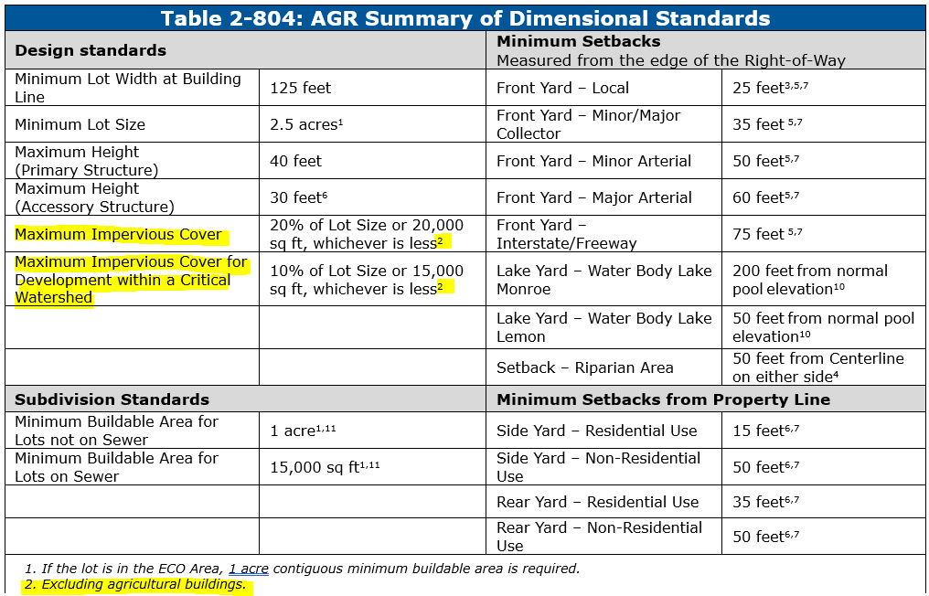
13. Question: Will the new impervious cover limitation inhibit Agricultural buildings?
Answer: See superscript “2” in the dimensional standards for the Agricultural zone that exempts agricultural buildings from the total impervious cover maximum calculation. This superscript exists in all eight (8) of the zoning districts as drafted (AGR, FOR, CVR, RNH, RES, LD, CD, and HD):
14. Question: How will minimum lot size for RES property owners with less than 1 ac impact possible nonconformity status?
Answer: The Residential 1 zone “Minimum Lot Size” criteria under Chapter 805 has a superscript by the “1 acre”. The superscript reads “11. If all other design standards are met, no variance is required for a lot of record with an area less than one (1) acre.” Therefore, as long as a RES property owner can meet required setbacks, maximum height, maximum impervious cover, etc, they do not need a variance if the lot size is under 1 acre.
15. Question: Will the building heights create more barriers for development, specifically residential development?
Answer: See the definition of building height (not changing from the current zoning ordinance):
Building Height: The vertical distance measured from the sidewalk level or its equivalent established grade opposite the middle of the front of the building to the highest elevation of the roof in the case of a slant or flat roof; to the deck line of a mansard roof; and to the mean height level between eaves and ridge of a gable, hip or gambrel roof; provided that where buildings are set back from the street line, the height of the building may be measured from the average elevation of the finished lot grade and the front of the building.
We have had very few variance requests (3 height variances in 14 years – one commercial height variance in a Agricultural zone; one accessory structure height variance; and one primary residential structure variance) for height maximums in the residential zones. Staff does not see a need to increase the height limits. With the consolidation of zones, however, we acknowledge that some current properties will be faced with a more stringent height limit.
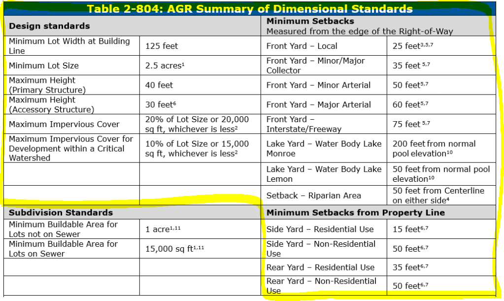
16. Question: How will the new minimum buildable area language in the CDO will impact lots for development?
Answer: The dimensional standard tables are set up to show both development standards, and subdivision standards, all in one table. The highlighted portion of the table 2-804 (see image to the right) would apply to development, whereas the non-highlighted portion of the table with “Subdivision Standards” would apply to only lots wanting to subdivide. Therefore, an existing AGR lot that does not have at least 1 acre of buildable (provisions for lots not on sewer), it would not require a variance if only requested development such as a building permit. However, we are still requiring structures to be located within buildable area.
17. Question: Why is the Community Development Lot width 60 feet, while Low Development (larger lots) has a lot width of 50 feet?
Answer: Staff made the change since this appeared to be in error. CD now exhibits a lot width of 55 ft in the current draft and LD is 60 ft. It is currently 75 ft for the LD equivalent and 60 ft for the CD equivalent. The CDO is becoming less restrictive in terms of lot width. However, setbacks are still 10 feet from either side in the CD zone and therefore, that part is staying consistent. In other words, the smaller lot width may occur, but it would not allow for smaller setbacks and therefore is self-limiting.
18. Question: Can the CDO allow dedicated right-of-way to be counted towards minimum lot size requirements?
Answer: This is undergoing review by our Legal Department. We acknowledge that when Right-of-way is dedicated during the subdivision platting process, it is considered to be an easement to the County. If future right-of-way improvements are required, the County could utilize that easement area to expand the roadway, improve stormwater infrastructure, etc. Therefore, it may eventually become improved right-of-way and would limit the lot size for future planning. Do note that the “minimum buildable area” must exclude right-of-way due to the lack of being able to build in this area.
19. Question: How will staff communicate to applicants under review that the CDO will impact them?
Answer: We are communicating very clearly to people within our permitting software that they need to submit a “complete application” to be considered under the current ordinance. We are required to tell applicants what is needed for an application to be complete so we will continue with this process.
20: Question/Comment: Staff needs to review footnotes for properties within the Federal Aviation Administration (FAA) boundary and restrict height accordingly.
Answer: The airport overlay on the CDO map is expanding greatly. We believe this encompasses all area and we will be administering any additional height restrictions accordingly.
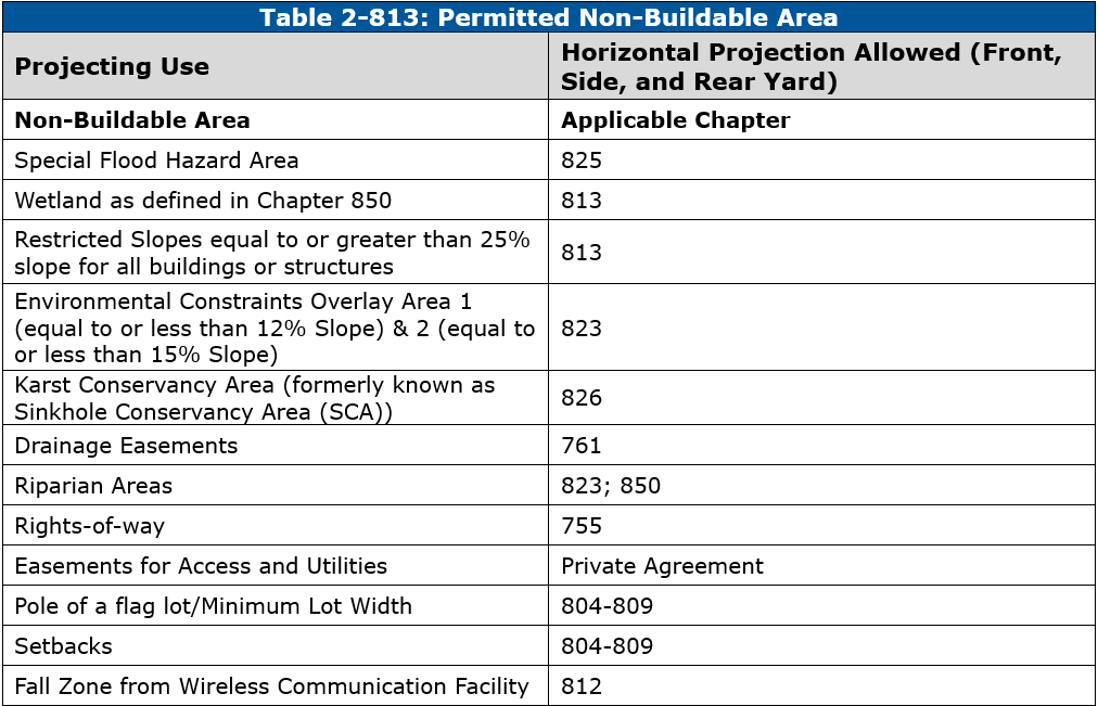
21. Question/Comment: Restricted Slopes are not defined in the CDO draft 9-11-2024?
Answer: See definition of buildable area and the latest iteration of the CDO for the non-buildable area table. Restricted slopes = 25% or greater slopes. This is not to be confused with the ECO Area Slope provisions. This has also been fixed in the Subdivision chapter 832-7.
Buildable Area: A designated area of a lot that is compact in form and necessary for the safe construction or placement of structures and associated utility infrastructure. Defined as land that is void of restricted slopes, karst, Special Flood Hazard Areas, easements for drainage ways or access, rights-of-way, setbacks, etc. Table 2-813 designates areas excluded from the buildable area (non-buildable areas).
22. Question: Can the Plan Commission consider including a zoning category between 0.5 and 0.6 acres?
Answer: There was a request for a 0.67 acre zoning district. This was put into an earlier draft of the CDO (reference a placeholder in 8/16/2024 draft). After discussing this with the Plan Commission, it was determined to remove this additional zone. No properties were zoned for 0.67 acre minimum lot size.
The gap between the Low Development (0.34 ac) and the Residential 1 (1-acre) zones has a lot to do with the septic system land requirements. Additionally, the RES zoning district allows development to occur on lots less than 1 acre if all other design standards are met.
23. Question/comment: I believe the Floodway fringe areas should not be included in “non-buildable” areas.
Answer: See Table 2-813 (image above) for calculating non-buildable area. We have included generally “Special Flood Hazard Area” as non-buildable, which includes floodway fringe areas. However, it can be calculated in the minimum lot size classification. Floodway fringe does have limitations and requires local floodplain development permits. When people purchase a lot with a minimum amount of “buildable area” they typically do not associate it with getting floodplain development permits. The Special Flood Hazard Area is defined as:
Special Flood Hazard Area (SFHA): Synonymous with “areas of special flood hazard” and floodplain, means those lands within the jurisdiction of Monroe County and the Town of Stinesville subject to a one percent (1%) or greater chance of flooding in any given year. Special flood hazard areas are designated by the Federal Emergency Management Agency on Flood Insurance Rate Maps, Flood Insurance Studies, Flood Boundary and Floodway Maps and Flood Hazard Boundary Maps as Zones A, AE, AH, AO, A1 30, A99, or VE. The SFHA includes areas that are flood prone and designated from other federal, state or local sources of data including but not limited to best available flood layer maps provided by or approved by the Indiana Department of Natural Resources, historical flood information reflecting high water marks, previous flood inundation areas, and flood prone soils associated with a watercourse.
Comments/Questions about the Use Table in the CDO:
24. Comment: Self Storage Stating “Rooftop solar panels shall be required for self-storage facilities” should be removed.
Answer: This has been removed from the latest draft of the CDO per a conversation with Legal.
25. Comment: Do not require a shared driveway for a DADU, especially if environmental conditions prevent sharing.
Answer: This standard is also in the Highway ordinance regarding one driveway per lot. In order to change this standard, it would also have to be amended in Chapter 755. If there are environmental issues preventing the sharing of a driveway, it could be evidence for variances/appeals to the standards in the Planning and Highway ordinances.
26. Question/Comment: wastewater treatment use should be allowed in all zones, conditional in residential, permitted in all others.
Answer: This is reflected in the latest CDO draft.
27. Comment: Adaptive Reuse Standard – façade improvement as an option is too broad. Should be spelled out specifically.
Answer: See Table 811-2 in the CDO. We believe it does provide examples and is clear.
28. Comment: remove standard that says: “No center shall be approved within 500 feet of another center.” under the Child Care Center use.
Answer: Staff reviewed this limitation and did not find a limitation in the State Code. This was removed based on feedback from the Legal Department.
General Comments/Questions for the CDO:
29. Question: Can Staff make sure that state statute rules are reflected in the CDO?
Answer: We are actively working with the County Legal Department to match terminology, update ordinance restrictions, etc to be in line with the state code.
30. Question: Can the Planning Staff calculate the total land area that is “unbuildable”?
Answer: This could be requested by the Plan Commission for staff to assess. However, we have inversely calculated the acreage in each zoning district, the amount of vacant land in each district, which we believe could be more useful.
31. Question/Comment: Transportation modalities should be highlighted in the CDO.
Answer: We will be working with the Parks Department to ensure trail maps are updated and can prompt connections and build out of planned trail facilities.
32: Comment: There were several comments made about taxes increasing as it relates to the zoning map changes.
Answer: Per Planning Department’s conversation with the Assessor’s Office: It is possible that a change in your zoning designation could impact a future property tax assessment. The main reasons property tax assessments can change is due to the property’s change in value (such as a sales disclosure) and it’s current use (existing and proposed development). Since a property’s zoning designation is tied to the value for which property can be sold for, whether it can be developed and to what extent, the use of the property, and whether land can be subdivided, it is possible zoning will impact your assessed value. Each of these aforementioned actions impact your assessed value. Therefore, the zoning designation of your property could be utilized to determine future tax assessment.
If you have questions about your assessed value (different from your tax bill) please call the Assessor’s Office at 812-349-2502. If you have tax bill questions, call the Treasurer’s office at 812-349-2530.
33. Comment: Concern about new and existing regulations impacting what people can and cannot do on their property as it relates to – livestock, business uses, subdividing.
Answer: Many regulations under the CDO are existing under the current ordinances. We encourage the public to be specific in their concerns so that we can review this on an individual basis.
34. Comment: There was a concern about urbanization of the County
Answer: Constituents are encouraged to review the zoning map changes and stay involved with the changes.
35. Comment: The reductions in land area for each zoning category should be placed in an appendix (or viewable to the public) from the current ordinance to the new.
Answer: See the “Analysis of Zoning Map Changes” on the monroecdo.com website (link: https://monroecounty99.sharepoint.com/:b:/s/mcplangroup/Eb_ElVAXo6FHgX5xXoAP-icBU8LXnDV8_3k3yTByXhSeGw?e=ZZjoei). We don’t think this is appropriate in the ordinance as it will cause confusion after any rezones take place after adoption of the CDO.
36. Comment: Do not infer zoning constraints on properties neighboring a trail/greenway, historical designation, etc.
Answer: We believe this is referring to conditions of approval that are placed by the Plan Commission. To our knowledge, there is not a zoning constraint on a neighboring property to an HP Overlay, nor a trail/greenway.
37. Comment: Buffer landscaping requirements are was too much. Flexible buffer requirements, incentives for landscaping, off-site landscape options should be included in the CDO. Please broaden the approved species list to reduce cost to developers.
Answer: The Landscaping ordinance does allow for double counting, specifically tree canopy can count towards required bufferyard requirements.
38. Question: The CDO notes that no certificate of occupancy shall be issued without completion of all landscaping shown on the landscape plan. The old ordinance allowed a conditional land use certificate/certificate of occupancy. Has this been removed?
Answer: In Chapter 841 under Land Use Certificates: “If the proposed use is in conformity with the provisions of this ordinance, except for final landscaping, a conditional Land Use Certificate may be granted at the Administrator’s discretion. The conditional Land Use Certificate shall be valid for no longer than six (6) months but may be renewed for an additional six (6) month period at the Administrator’s discretion”
39. Question: The old ordinance allowed for opaque fencing to reduce
plantings. Has this been removed?
Answer: No: “Bufferyard D Value reduction of 50 percent allowed if one of the following is installed within the Bufferyard:
a. A six-foot-high opaque fence or wall which completely blocks light from traveling through and the remainder of the required plantings to be installed adjacent to the fence on either side or;…”
40. Question: Numerous properties did not go through the site plan
approval process (ex: pre-existing nonconforming properties from
10 years ago, such as boat storage by the lake)
● Are they being zoned now to be in compliance?
● Same question for permitted uses?
Answer: many of the businesses that were in operation during the last ordinance and zoning map update in 1997 were zoned as “Pre-Existing Business” (PB). Staff has taken careful consideration in removing Pre-Existing Business zoning and transfer those business uses into either “Limited Business” or “General Business” zoning categories. If a property was not captured as PB zoning, we assume that the Plan Commission made a decision in 1997 to not call the boat storage conforming and to proceed as a non-conformity; we did not go back to capture non-conforming uses to become conforming. If a boat storage business has started since 1997 and were not zoned for said use, it would be considered an illegal use subject to enforcement. However, if a legal pre-existing boat storage location, such as one zoned PB, never went through the site plan process and has not undergone expansion, they would be able to go through the proper planning process under the CDO to receive approval. Some uses are changing from “permitted” to “conditional”. For instance, “Boat Storage” is currently “Permitted in LB, but under the CDO, the use changes to “RV and/or Boat Storage” and it is becoming “Conditional”.
41. Question: Have we contacted all PB-zoned property owners and had them weigh in on their new zoning?
Answer: we have spoken to several of them, and all owners received the legal postcard mailer.
42. Question: There were concerns raised about the ECO areas – are there any exclusions for running utilities since utility length adds to the cost of the development? Utility companies want to do the shortest route possible and along County roadways.
Answer: There is an exception for development of a single family residence and related utilities.
43. Comment: There was a concern for slope restrictions for ADA accessibility. There is a concern that land disturbance limitations may make it so that a home cannot be made with zero stair entry.
Answer: Under Chapter 823, there are standards for approving exceptions to the ECO area slope provisions. This section will include language regarding ADA accessibility to give the Planning Director administrative authority.
44. Comment: Regarding the karst and sinkhole development in the CDO: It would be very helpful to have the County MS4 present why these standards were set. Understanding the CDO must align with the Stormwater Ordinance, it will be helpful to update the Stormwater Ordinance to address the above concerns. The language would need to be clear and on who identify sinkholes such as engineers, certified geologist and have a sinkhole, how it is defined.
Answer: From the MS4 Coordinator for Monroe County: The Drainage Board settled on the 50 ft. KCA based on scientific studies focusing on water quality protection for sinkholes and the professional expertise of the geologists and engineers on the board. Here is the main study that was referenced at our meetings: https://pubs.usgs.gov/publication/70028991. It states that buffers at least 100 ft. are most effective but buffers around 50 ft. still provide good water quality protection while still being cost effective. We also incorporated the sinkhole drainage area delineation into the ordinance.
45. Question: Could a heat damage prevention section be added to the CDO?
Answer: This could be requested by the Plan Commission for staff to assess. We believe that the landscape chapter does help with “heat island” effects.
46. Comment: Outreach for new chapter of the Lake Lemon Overlay is needed. Most people don’t know about this. There was also a concern about the relationship of this and Flood Damage Protection ordinance. Concern about limitations to dredging and the 50 ft setback requirement under this overlay.
Answer: All property owners in the County jurisdiction were sent a postcard with the information for the CDO hearing on 9/24/2024. In addition, we have met with Adam Casey, the District Manager for the Lake Lemon Conservancy. Adam has agreed to send further individualized communication out to Lake Lemon property owners. The communication states:
The Monroe County Planning Department is updating the Zoning and Subdivision Control Ordinances for the County, as well as updating the zoning map for the County (generally called the “County Development Ordinance”, or “CDO”). More information on this process can be found here: https://monroecdo.com/. The Lake Lemon Overlay does have exceptions for municipalities, and we believe that with proper permitting, we would not be removing the ability of the Lake Lemon Conservancy District to maintain the shoreline, or conduct dredging operations.
The CDO has a new section regarding a “Lake Lemon Overlay” which encompasses the watershed area for Lake Lemon. This means that if you own property around Lake Lemon, you will likely see your zoning change to incorporate both an underlying zone (i.e. Residential 1 zone) with a “Lake Lemon Overlay”. The main change under the Lake Lemon Overlay will be a setback for structures of 50 feet from the normal pool elevation of Lake Lemon. To find out what this means for your property, please call the Planning Office at 812-349-2560 and ask to speak with the “Planner of the Day”.
There will also be added uses into the CDO, such as “Short-Term Rental – Owner Occupied” which will now be permitted in many zones near Lake Lemon.
Please don’t hesitate to reach out with questions by phone (812-349-2560) or email (PlanningOffice@co.monroe.in.us). We have completed the public hearing portion for the CDO and are anticipating adoption by the Board of Commissioners by the end of this year.
47. Comment: The flood damage prevention ordinance would impact a property and could render some properties as non-buildable.
Answer: The flood damage prevention ordinance is a model ordinance provided to the County by the State Department of Natural Resources. In order to qualify for flood insurance, we must adopt the ordinance as given to us by the State. There has been very minor changes to the draft given to the Planning Department, and largely to coordinate consistent terminology. Any land owner concerned about the impact of the flood damage prevention ordinance and their ability to develop/subdivide should contact the Planning Department.
48. Question: What land use provisions are being made for the unhoused in our community?
Answer: See the following uses: “Emergency Housing or Short-Term Shelter” for after natural disasters; “Long-Term Shelter”; “Residential Facility for Mentally Ill Individuals”; “Residential Facility for Developmentally Disabled”
49. Comment:There appears to be conflicts in the summary tables/ “zoning cards” /two-pagers and the land use table.
Answer: Staff is continuing to make updates to the Land Use Table and will double check the summary tables at the end. In the event of conflict, the Land Use Table will control.
50. Question: Can the administrator have discretion regarding Unlisted Land Uses (i.e. uses not in the Land Use Table)?
Answer: Legal has requested that we not have a process for unlisted uses as it gets into more of a PUD consideration than administrative discretion.
51. Comment: Concern for building permit costs, timelines for permit review and process.
Answer: By the state code, the Planning Department has 12 business days to review a complete application and issue a response or proceed with permit issuance. Fees by the Building Department and Planning Department are not tied under the CDO and instead are separate documents that can be changed without undergoing an ordinance revision. For questions about the Building Department fees, call 812-349-2580.
52. Question: Does the lighting chapter limits conflict with the Building Code? Could pictures be included in the ordinance to show what the lighting would look like?
Answer: From the Building Commissioner: “Very rarely are (lighting) maximums provided in the Building Code, there are some sections that will require a (lighting) minimum, particularly around larger commercial buildings…I cannot believe that there would be a conflict. Without too much detail, unless you want it, when buildings required two exits the “Exit Discharge” must be lit to a public way. This requirement is 1 foot candle at the walking surface. (which is generally just enough to see the shadow of your foot) What that works out to be at the source, is something I don’t know how to answer as there are too many variables.” Planning Staff believes that the lighting source at the buildings will not counteract with the lighting ordinance regarding “trespass” across property lines as buildings, and therefore the lighting source, have to meet proper setbacks.
53. Comment: Different housing types are needed throughout the County; specifically request for single family paired homes; accommodation for seniors are needed.
Answer: See the Land Use Table for all housing options. We believe these requests are built into the draft CDO.
Comments/Questions about the Zoning Map:
54. Comment: It appears the zoning map is going off of the parcels and not using deeds to determine if parcels are truly separate.
Answer: Staff has been reviewing properties that appear “split zone” and making those fixes. Please reach out to the Planning Department if your property shows as being “split zoned” on the CDO map.
55. Question: Can the floodplain be included as a zoning overlay?
Answer: No, we cannot create a floodplain zone as it is subject to change and we are required to go by the DNR’s map. There is a formal process for changing the floodplain and it does not involve a rezone through the County Commissioners. We must follow the procedures set forth by the State to remain eligible for flood insurance.
56. Question: There is a concern about losing 9,000 acres out of residential zone.
Answer: This information is outdated. Please see the latest conversion chart.
